Millions of people around the world are turning their eyes to the sky this week not through telescopes, but through the screens in their homes. Thanks to NASA’s live satellite tracker tools and real-time camera feeds from the International Space Station (ISS), anyone on Earth can watch our planet from space, completely free and without any subscription. And right now, the timing could not be more extraordinary.
NASA offers several powerful, free tools that let the public track satellites and watch a live Earth satellite view in real time. From the iconic ISS live camera feed to the NASA Worldview data platform and the brand-new Artemis Real-time Orbit Website (AROW), space has never felt closer to home. This week, as NASA’s historic Artemis II mission carries four astronauts on a journey around the Moon the first crewed lunar voyage in over 50 years these tools are giving the world a front-row seat to history.
Background: The World’s Most Watched Planet
Humanity’s fascination with seeing Earth from above is nothing new. But in 2026, the technology behind NASA’s live satellite tracking systems has reached a level of quality and accessibility that was unimaginable even a decade ago. High-definition video streams, interactive orbit maps, and real-time satellite data are now available to anyone with a smartphone or internet connection.
The International Space Station, orbiting at approximately 408 kilometers above Earth, has long been the backbone of NASA’s public-facing live video feeds. The station completes roughly 16 orbits of the planet every single day, meaning that at any given moment, its cameras are pointed at a different part of the globe.
Now, with the launch of Artemis II on April 1, 2026, a new chapter in live space tracking has opened one that extends far beyond Earth’s orbit and toward the Moon itself.
Details: NASA’s Live Satellite Tracker Tools Explained
1. The ISS Live Camera A Real-Time Earth Satellite View
The most popular way to watch an Earth live satellite feed is through the ISS External High Definition Camera (EHDC). This replaced the earlier High Definition Earth Viewing (HDEV) experiment, which operated from 2014 to 2019, and now provides a crystal-clear public video stream directly from orbit.
The camera feed is 100% real not computer-generated. NASA’s cameras transmit live footage via the Tracking and Data Relay Satellite (TDRS) system to mission control in Houston, and from there, it is streamed to the world. When the ISS is on the night side of Earth, the feed goes dark due to lack of sunlight, but daylight returns within about 45 minutes as the station completes its orbit.
Additionally, the commercial partner Sen.com provides ultra-high-definition 4K streaming from the ISS, offering even sharper views of continents, oceans, weather systems, and city lights at night.
2. NASA Worldview The Ultimate Earth Live Satellite Map
For those who want more than a passive video feed, NASA Worldview (available at worldview.earthdata.nasa.gov) is one of the most powerful free tools on the internet. It is an interactive interface that lets users browse full-resolution, global, daily satellite imagery covering over 1,200 visualized satellite data products.
Much of this imagery is available within hours of being captured, making it as close to a real-time Earth satellite map as current technology allows. The platform supports critical applications such as wildfire tracking, flood monitoring, air quality measurements, and storm analysis. Users can animate imagery over time to observe how conditions have changed across days, weeks, or years.
NASA Earthdata is currently in the process of migrating all Earth science data into a unified platform, a transition expected to be complete by the end of 2026.
3. NASA Eyes on the Earth A 3D Satellite Tracker
NASA’s “Eyes on the Earth” application, accessible through eyes.nasa.gov, is a stunning 3D visualization tool that allows users to explore the planet and track NASA’s fleet of Earth-observing satellites in real time. It shows where each satellite is located, what data it is collecting, and how it contributes to our understanding of climate, weather, and the environment.
The platform is available as both a browser-based experience and a downloadable application, making it a versatile option for students, educators, researchers, and curious minds alike.
4. AROW Track Artemis II Live, Right Now
Perhaps the most exciting new addition to NASA’s live tracking ecosystem is the Artemis Real-time Orbit Website, known as AROW. Launched alongside the Artemis II mission, AROW allows anyone with internet access to track the exact position of the Orion spacecraft as it travels toward the Moon and back.
Using data sent directly from sensors aboard Orion to NASA’s Mission Control Center in Houston, AROW provides constant updates on the spacecraft’s distance from Earth, distance from the Moon, mission duration, and current orbital path. Users can also view information about Apollo landing sites on the lunar surface. The mobile version of AROW even includes an augmented reality tracker, allowing users to point their phones at the sky to see where Orion is relative to their position on Earth.
NASA Live Satellite Download: How to Access These Tools
All of NASA’s primary satellite viewing and tracking tools are free to download and use. Here is a quick guide:
NASA Eyes on the Earth Download available at eyes.nasa.gov for desktop computers (Windows and Mac). The app provides the full 3D satellite tracking experience with offline capabilities.
ISS Live Now App Available on both the Google Play Store and Apple App Store, this third-party app aggregates NASA’s live ISS camera feeds, provides an interactive ISS tracker with real-time location, altitude, and speed, and notifies users of upcoming ISS passes overhead.
NASA+ Streaming Service NASA’s official streaming platform requires no subscription and is available on iOS, Android, web browsers, and most smart TV platforms. It provides live mission coverage, including ongoing Artemis II broadcasts and ISS live views.
NASA Worldview Accessible directly through any web browser at worldview.earthdata.nasa.gov, with no download required.
AROW (Artemis Real-time Orbit Website) Available online and as a mobile app for iOS and Android, free of charge.
Quotes: Voices From Space
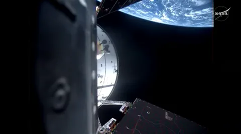
NASA astronaut and Artemis II pilot Victor Glover, speaking live from orbit aboard the Orion spacecraft on April 2, 2026, offered a perspective that resonated with people watching from Earth below. Reflecting on the view of their home planet from space, Glover said the experience reminded him that despite all differences, humanity is ultimately one people a sentiment that echoed the mission’s overarching theme of unity and exploration for all humankind. Commander Reid Wiseman, before receiving final launch clearance on April 1, declared simply: “We go for all of humanity.”
NASA has emphasized throughout the mission that the live camera feeds from Orion, streamed continuously via NASA+ and YouTube, offer the public an unprecedented window into deep space travel not just as spectators, but as participants in humanity’s return to the Moon.
Impact: Why NASA’s Live Satellite Tools Matter Globally
The global reach of NASA’s live satellite tracking tools is enormous. The ISS live feed has been watched by hundreds of millions of people over the years, serving as a powerful reminder of Earth’s beauty and fragility. Tools like NASA Worldview have become essential for emergency responders tracking wildfires and floods, meteorologists studying storm systems, and scientists monitoring the effects of climate change.
For educators and students, these platforms make space exploration tangible and interactive. A student in Karachi or Lagos can observe the same live satellite view of Earth as a researcher at NASA’s Jet Propulsion Laboratory a democratization of data that has real scientific and educational value.
The Artemis II mission adds a new dimension to this global participation. With AROW tracking the Orion spacecraft in real time, millions of people can follow four astronauts as they travel farther from Earth than any humans have journeyed since Apollo 13 in 1970 a record-breaking distance of over 252,799 miles from our planet.
Furthermore, Artemis II carries historic firsts: the crew includes the first Black astronaut, the first woman, and the first non-American ever to venture toward the Moon. This mission is not just a technological achievement it is a cultural and historic milestone for the world.
Conclusion: A New Era of Open Space Exploration
The combination of NASA’s live satellite tracker tools, ISS camera feeds, and the Artemis II mission represents a defining moment in how humanity experiences space exploration. For the first time, the journey to the Moon is being shared with the entire world in real time through phones, laptops, and smart TVs, in homes and classrooms across every continent.
As the Artemis II crew continues their approximately 10-day mission around the Moon and back to Earth, NASA is also looking ahead. Artemis III and Artemis IV are planned to achieve a crewed lunar landing by 2028, with eventual crewed missions to Mars on the long-term horizon. Each step forward will be tracked, streamed, and shared because space, as NASA continues to prove, belongs to everyone.
Frequently Asked Questions (FAQs)
Can I watch Earth live?
Yes, absolutely. NASA provides a free, live HD camera feed from the International Space Station that streams continuous real-time video of Earth from approximately 408 kilometers above the surface. You can watch it through NASA’s YouTube channel, the NASA+ streaming service (available on all major platforms with no subscription required), or through third-party apps like ISS Live Now. When the ISS is on the dark side of Earth, the feed temporarily goes black, but daylight views resume within about 45 minutes as the station completes its orbit. Additionally, NOAA’s NESDIS platform offers interactive real-time satellite maps of global weather and environmental conditions.
Is NASA going to the Moon in 2026?
Yes and it has already launched. NASA’s Artemis II mission lifted off from Kennedy Space Center on April 1, 2026, carrying four astronauts on a historic 10-day journey around the Moon and back to Earth. This is the first crewed lunar mission in more than 50 years. The crew NASA astronauts Reid Wiseman, Victor Glover, and Christina Koch, along with Canadian Space Agency astronaut Jeremy Hansen are aboard the Orion spacecraft, which launched atop NASA’s Space Launch System rocket. While Artemis II does not include a lunar landing, a future mission, Artemis III, is planned to land astronauts on the Moon’s surface by 2028.
Can I use NASA Eyes on my phone?
Yes, with some nuance. The full NASA Eyes on the Earth desktop application is designed primarily for Windows and Mac computers and offers the richest 3D tracking experience with downloadable content. However, NASA’s AROW (Artemis Real-time Orbit Website) which is part of the broader NASA Eyes ecosystem for the Artemis program is fully available as a mobile app for both iOS and Android devices. It even includes an augmented reality feature that lets you point your phone at the sky to see where the Orion spacecraft is in relation to your current location on Earth. For general Earth satellite browsing on mobile, NASA Worldview is also accessible through any mobile web browser.