

A deadly Mount Dukono eruption on Friday, May 8, 2026, killed three hikers and left ten more missing on Indonesia’s Halmahera island. The Volcanological Survey of Indonesia had already placed the volcano on alert and banned visitors from approaching the crater. Authorities say the hikers ignored all warnings.
Mount Dukono Eruption What Happened on May 8
Three hikers, including two foreigners, died and ten were missing after Mount Dukono on Indonesia’s eastern Halmahera island erupted on Friday, spewing an ash cloud about 10 kilometres into the air.
According to Indonesia’s BNPB disaster mitigation agency, five climbers were also injured in the eruption. The eruption sent shockwaves through the region and triggered an emergency rescue operation in extremely difficult terrain.
Seven people had come down safely, but 10 more were missing in an area declared off-limits to visitors last month after scientists observed an increase in volcanic activity. The Mount Dukono eruption is now one of the deadliest volcanic incidents in Indonesia in recent years.
Mount Dukono Background and Location
Mount Dukono is an active stratovolcano located in North Halmahera Regency, North Maluku Province, in eastern Indonesia. On a Mount Dukono map, it sits on the northern tip of Halmahera island, one of the most volcanically active regions in the entire Indonesian archipelago.
Mount Dukono has been one of Indonesia’s most persistently active volcanoes for decades. The Mount Dukono last eruption before this tragedy was not a single event the volcano has been in a near-constant state of activity, with regular ash emissions and small explosive episodes recorded over many years by the Volcanological Survey of Indonesia.
Indonesia, a vast archipelago nation, experiences frequent seismic and volcanic activity due to its position on the Pacific “Ring of Fire” where tectonic plates collide. The Southeast Asian country has nearly 130 active volcanoes.
Volcanological Survey of Indonesia Had Issued Clear Warnings
The Volcanological Survey of Indonesia, operating through its agency PVMBG (Centre for Volcanology and Geological Hazard Mitigation), had been closely monitoring Mount Dukono and warning the public for weeks.
Mount Dukono is currently on level two of Indonesia’s four-tiered alert system. Since December, the Centre for Volcanology and Geological Hazard Mitigation (PVMBG) has recommended that tourists and climbers do not come within four kilometres of the volcano’s Malupang Warirang Crater.
The Volcanological Survey of Indonesia had done its job. Warning signs were posted at the trail entrance. Social media alerts had been circulated. Yet the hikers still climbed Mount Dukono, ignoring every precaution put in place.
The Mount Dukono Hike A Deadly Gamble
The Mount Dukono hike has gained popularity in recent years among adventure travelers and social media content creators. The trail offers dramatic views of an active crater, making it visually spectacular and dangerously tempting for those seeking viral content.
Police chief Erlichson Pasaribu of North Halmahera district said the hikers had ignored social media appeals and warning signs put up at the entrance to the trail to stay away. He added: “Local residents understand and don’t want to climb. Many hikers are foreign tourists who wish to create social media content.”
The Mount Dukono hike is not a regulated tourist activity. The Volcanological Survey of Indonesia and local authorities have repeatedly urged the public to treat this as a restricted zone, not a trekking destination. This tragedy is a grim consequence of ignoring expert advice for the sake of social media fame.
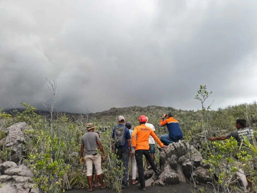
Rescue Operations Difficult Terrain Slows Response
Rescuers from multiple agencies rushed to the site following the Mount Dukono eruption, but the operation has been extremely challenging due to the volcano’s rugged geography.
“The joint teams from the Regional Disaster Management Agency (BPBD) and the National Search and Rescue Agency (Basarnas) continue to conduct sweeps and evacuations of climbers in the mountain area as volcanic activity increases,” said BNPB spokesman Abdul Muhari.
Police chief Erlichson said the rescue operation was taking place in rough terrain, only accessible to vehicles part of the way up the slope. “The rest of the way the victims need to be carried on a stretcher. And there is still rumbling from the eruption. It slows down our evacuation,” he said.
As of Friday, search teams were still sweeping the mountain, and the fate of the ten missing hikers remained unknown.
Ash Cloud Threatens Nearby Cities and Health
Beyond the immediate deaths and missing persons, the Mount Dukono eruption has created a broader public health and transportation concern for surrounding areas.
Lana Saria, head of the government Geology Agency, said the early-morning eruption was accompanied by a “booming sound” and a thick smoke column rising around 10 kilometres from the summit of Mount Dukono.
“The direction of the ash distribution leans northward, so residential areas and Tobelo City need to be vigilant for volcanic ash rain,” she warned. The smoke could be dangerous for public health and risked disrupting transportation services.
Residents in the region have been advised to wear masks and stay indoors where possible as ash continues to fall across northern areas of Halmahera island.
Mount Dukono Singaporean Hikers Foreign Nationals Among Victims
Reports confirm that among the dead were foreign nationals, raising questions about how overseas tourists are accessing restricted volcanic zones in Indonesia. While the term “Mount Dukono Singaporean” has been circulating in regional social media discussions, Indonesian authorities have not officially confirmed the nationalities of the two foreign hikers as of Friday.
“There are three dead, two foreigners and one resident of Ternate island in eastern Indonesia,” confirmed police chief Erlichson Pasaribu. The identities and nationalities of the foreign victims are currently being verified by authorities.
This incident has prompted calls in Indonesia and neighboring countries for stricter border-level advisories regarding volcanic hiking zones particularly for tourists who may not be familiar with local warning systems or the Volcanological Survey of Indonesia’s active monitoring alerts.
Indonesia’s Volcanic Danger A Recurring Crisis
Indonesia has one of the densest concentrations of active volcanoes in the world. The Mount Dukono eruption is not an isolated event but part of a long pattern of volcanic tragedies in the archipelago.
The Volcanological Survey of Indonesia monitors dozens of active volcanoes around the clock. Despite world-class monitoring infrastructure, the country continues to face deaths because warnings are ignored, especially by foreign tourists who treat volcanoes like tourist attractions rather than geological hazards.
Volcanoes like Merapi, Sinabung, Semeru, and now Mount Dukono have all claimed lives in recent years under similar circumstances people entering restricted zones against official advice. Indonesia’s government is now under pressure to tighten enforcement on Mount Dukono hike routes and similar trails across the country.
Conclusion Warnings Were There, and Lives Were Lost
The Mount Dukono eruption of May 8, 2026 is a preventable tragedy. The Volcanological Survey of Indonesia had done everything right it monitored the volcano, raised the alert level, banned visitors, and posted warnings at the trailhead. What failed was human judgment.
Three people are dead. Ten are still missing. Five are injured. And rescue teams are risking their own lives in active volcanic terrain to bring victims home. As Indonesia confronts this disaster, the message from the Mount Dukono map to the highest levels of government is the same: volcanic zones are not content opportunities they are lethal environments that demand respect.
The coming days will determine whether the missing hikers are found alive, and whether Indonesia will enforce stricter penalties for those who defy volcanic exclusion zones in the future.
FAQs
How many died in the La Palma eruption?
The 2021 Cumbre Vieja volcanic eruption on La Palma island in Spain’s Canary Islands did not directly cause any confirmed deaths from lava or ash. However, one person died from a cardiac arrest during evacuations. Thousands were evacuated and over 3,000 buildings were destroyed. It was considered one of the most destructive eruptions in Spain’s recent history.
How many bodies were recovered from Whakaari?
The December 2019 eruption at Whakaari (White Island) in New Zealand killed 22 people. Initially, two bodies were not immediately recovered due to the danger of re-entry. Eventually, all 22 victims were confirmed dead, with recovery operations taking place over several weeks in extremely hazardous conditions.
What are the top 3 deadliest volcanoes?
The three deadliest volcanic eruptions in recorded history are Mount Tambora in Indonesia (1815), which killed an estimated 71,000 people directly and caused widespread famine; Krakatoa in Indonesia (1883), which killed over 36,000 people, mostly from tsunamis; and Mount Pelée in Martinique (1902), which destroyed the city of Saint-Pierre and killed approximately 30,000 people. Indonesia appears twice on this list a sobering reminder of why the Volcanological Survey of Indonesia’s warnings must never be ignored.