
A powerful storm now being called Super Typhoon 2026 has torn through several US Pacific islands, bringing destructive winds, heavy rainfall, and dangerous storm surges along with it. Emergency officials say homes, roads, power infrastructure, and public buildings have all taken significant damage, and rescue and recovery work is still underway.
Residents have been told to stay indoors, avoid flooded areas, and follow evacuation orders wherever they apply. Emergency crews are still assessing just how bad the damage is while working to get essential services back online.
Some Background
The Pacific Ocean produces some of the strongest tropical cyclones anywhere in the world every year. When these storms form in the western Pacific, they’re called typhoons; the same kind of storm in the Atlantic or eastern Pacific gets called a hurricane instead.
Meteorologists reserve the “super typhoon” label for only the most intense storms ones with extremely high sustained wind speeds and serious destructive potential.
This latest storm ranks among the strongest to hit the region this season, and it triggered widespread emergency preparations well before it made landfall.
The Damage So Far
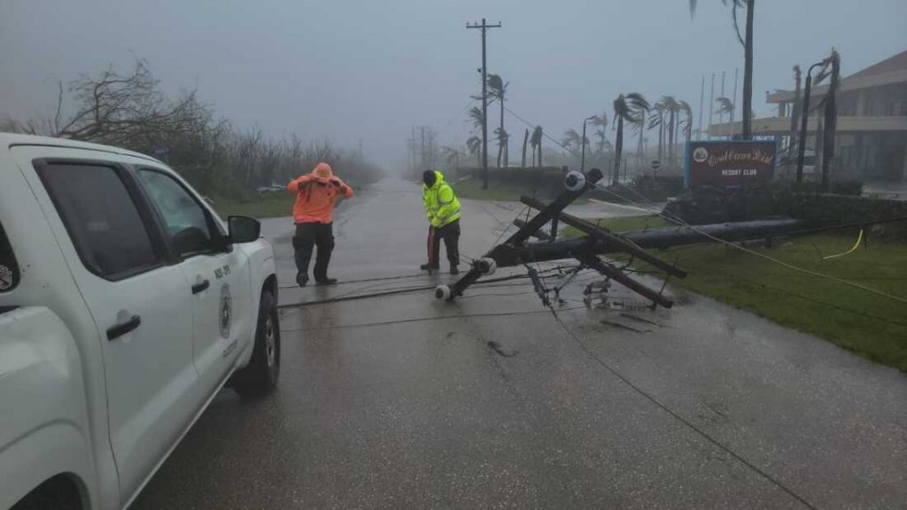
The storm brought hurricane-force winds that tore through homes, schools, government buildings, and businesses alike.
Large trees were ripped out of the ground, power poles came down, and transportation networks were badly disrupted. Heavy rain also flooded low-lying communities, which has made rescue work even trickier.
Authorities are still surveying the affected areas to get a full picture of the destruction.
Emergency Crews on the Ground
Emergency agencies had their disaster response plans in motion well before the storm hit.
Search and rescue teams have been sent out to help stranded residents, and shelters are still housing families who’ve been displaced from their homes.
Medical staff remain on standby, ready to treat injuries and support communities dealing with the aftermath.
Where the Storm Stands Now
Meteorologists are keeping close tabs on the system as it gradually moves away from the islands it hit.
Wind speeds should ease up over time, but heavy rain, rough seas, and dangerous coastal flooding are still very much possible in several areas.
Officials are still advising people to avoid unnecessary travel until conditions clearly improve.
What Makes a Storm a “Super Typhoon”
The “super typhoon” label gets attached to only the most powerful tropical cyclones in the western Pacific, based on how strong their sustained winds are.
These storms can generate destructive winds, torrential rain, storm surges, and severe flooding across huge areas.
Because of just how powerful they are, super typhoons usually call for extensive evacuation planning and a serious emergency response.
Super Typhoon vs. Hurricane What’s the Difference?
A lot of people wonder what actually separates a super typhoon from a hurricane.
The short answer: not much, physically speaking. Both are tropical cyclones with similar characteristics the real difference comes down to where they form and what they’re called there.
Storms in the Atlantic and eastern Pacific are hurricanes; the same kind of storm in the western Pacific is a typhoon. “Super typhoon” specifically refers to the strongest of those, the ones with especially high sustained wind speeds.
Just How Fast Are These Winds?
One of the scariest things about a super typhoon is the sheer intensity of its winds.
Wind speed here gets measured by sustained winds, not just the occasional gust and the stronger those sustained winds are, the bigger the storm surge, the bigger the waves, and the more structural damage you can expect.
Meteorologists track all this constantly using satellites, aircraft reconnaissance, radar, and ocean monitoring equipment.
How Does This Compare to Past Storms?
Weather experts have already started drawing comparisons between this storm and other historically devastating Pacific cyclones.
Super Typhoon Yolanda one of the most powerful tropical cyclones ever recorded, infamous for the devastation it caused in the Philippines back in 2013 keeps coming up in these conversations.
No two storms are exactly alike, but these comparisons help emergency planners think through possible risks and shape their response.
Is This the Same as Super Typhoon Uwan?
Search interest in Super Typhoon Uwan has spiked since this new storm made headlines.
To be clear, meteorologists point out that every tropical cyclone gets its own name under official regional naming systems. This current storm is a separate event and shouldn’t be mixed up with previous typhoons that had different names.
Official weather agencies are putting out updates as the situation develops.
Staying Safe After the Storm
Authorities are urging people to stay alert even once the worst of the wind has passed.
Floodwater, damaged buildings, downed power lines, and disrupted roads can all keep posing risks for days after a storm like this makes landfall.
The advice from emergency agencies is simple: keep checking official weather updates and follow local evacuation guidance where it applies.
The Wider Impact
The storm has thrown a wrench into transportation, shipping, tourism, and communication across parts of the Pacific.
Airlines have had to adjust flight schedules, and maritime authorities have issued warnings for vessels near the affected waters.
International humanitarian groups are also watching closely, ready to step in with support if it’s needed.
Clearing Up Some Confusion Online
With all the media coverage, some people have been searching for things like a “super typhoon movie” while trying to find information about what’s happening.
Just to be clear while there are films and documentaries about major storms, this is a real, ongoing weather emergency affecting actual communities in the Pacific. It’s not to be confused with anything fictional.
Sticking to official weather updates is the safest bet during an active emergency like this.
What Recovery Looks Like
As conditions gradually improve, damage assessments will keep going across all the affected islands.
Power companies, emergency crews, and public works teams have already started restoring electricity, clearing roads, and fixing damaged infrastructure.
Depending on just how bad the destruction turns out to be, full recovery could take several weeks.
Bottom Line
Super Typhoon 2026 is a fresh reminder of just how much damage powerful tropical cyclones can do across the Pacific. Emergency prep helped in some areas, but the damage overall has still been significant.
Authorities are asking residents to stay cautious as recovery continues, and weather agencies will keep tracking the storm’s movement and issuing updates as things change.
Frequently Asked Questions
What was Super Typhoon Bavi?
Super Typhoon Bavi was a powerful tropical cyclone that formed in the western Pacific during the 2020 typhoon season. It reached super typhoon strength while still out over open water, but weakened before actually making landfall. Even so, it triggered evacuations and severe weather warnings across several East Asian countries thanks to strong winds, heavy rain, and dangerous coastal conditions.
What’s the biggest super typhoon in history?
A handful of storms are usually mentioned in this conversation Typhoon Tip from 1979, Super Typhoon Haiyan (also known as Yolanda) from 2013, and a few other exceptionally intense Pacific cyclones. “Biggest” can mean different things depending on whether you’re measuring wind speed, central pressure, physical size, or overall impact. Haiyan in particular remains one of the deadliest and most destructive tropical cyclones on record.
What category did Typhoon Bavi reach?
Bavi hit super typhoon intensity while it was out over the western Pacific, based on its sustained wind speeds. That said, the exact category can vary a bit depending on which weather agency’s classification system you’re looking at. By the time it got close to land, Bavi had weakened from its peak but it still brought heavy rain, strong winds, and dangerous coastal conditions with it.