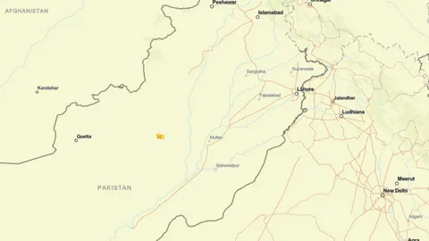
An earthquake northern Pakistan PMD has officially recorded at a magnitude of 5.3 struck the Gilgit-Baltistan region, with the epicentre located near Barishal at a depth of 10 kilometres.
The 5.3 magnitude earthquake struck near Barishal in Gilgit-Baltistan at a depth of 10 kilometres, with two additional tremors of magnitude 5.0 recorded in the same area within the same hour.
No casualties or major structural damage have been reported following the earthquake northern Pakistan PMD confirmation, though authorities have advised residents across the earthquake in northern areas of Pakistan to remain alert for aftershocks that may follow in the hours ahead.
Background
Earthquake Northern Pakistan PMD — Why This Region Shakes So Often
The earthquake northern Pakistan PMD recorded today is not an isolated event — it is the latest in a relentless seismic pattern that has defined the geology of Pakistan’s northern regions for millions of years.
Pakistan is one of the most seismically active countries in the world, being crossed by several major faults. Pakistan geologically overlaps both the Eurasian and Indian tectonic plates. Balochistan, the Federally Administered Tribal Areas, Khyber Pakhtunkhwa and Gilgit-Baltistan lie on the southern edge of the Eurasian plate on the Iranian Plateau, while Sindh, Punjab, and Azad Jammu and Kashmir lie on the north-western edge of the Indian plate in South Asia. Hence this region is prone to violent earthquakes as the two tectonic plates collide.
Pakistan falls on three major tectonic plates — the Arabian, Euro-Asian and Indian — creating five distinct seismic zones within the country.
The earthquake in northern areas of Pakistan is therefore not a random occurrence. It is a predictable consequence of living on one of the most geologically active collision zones on earth — where the Indian plate continues to push northward into the Eurasian plate at a rate of approximately 40 to 50 millimetres per year, generating the tectonic stress that produces the earthquake pakistan magnitude readings that the PMD monitors around the clock.
Details
Earthquake Northern Pakistan PMD — Full Incident Report
The earthquake northern Pakistan PMD recorded showed an epicentre at coordinates 36.555 North, 74.454 East near Barishal in Gilgit-Baltistan at a depth of 10 kilometres. Within the same period, a 5.0 magnitude quake was recorded at 36.647 North, 74.439 East and another 5.0 magnitude tremor at 36.673 North, 74.371 East — all clustered in the same Barishal zone of Gilgit-Baltistan, suggesting a swarm pattern of seismic activity in the northern areas.
Security and disaster management authorities dispatched teams to assess any structural damage following the earthquake in northern areas of Pakistan and confirmed no immediate reports of casualties or building collapses in the affected zone.
The PMD has stated in previous similar incidents that the epicentre of quakes registering in this region is typically located in the Hindu Kush region of Afghanistan or the Gilgit-Baltistan fault system at varying depths, and that the quake was felt across Islamabad, Rawalpindi, Peshawar, Chitral, Swat, Dir, and Malakand depending on the depth and magnitude of the event.
Pakistan’s Earthquake Pattern — The Numbers
The earthquake northern Pakistan PMD recording today sits within a statistical pattern that makes Pakistan one of the most earthquake-prone nations on earth.
Based on data from the past 26 years, there are about 328 earthquakes on average per year in Pakistan. Magnitude 7 or higher occurs approximately once every 9.7 years. Magnitude 6 or higher occurs approximately once every 1.2 years. Magnitude 5 or higher occurs approximately 11.7 times per year. Magnitude 4 or higher occurs approximately 175 times per year — or 14.6 times per month.
In the past 10 years, 2,402 earthquakes with a magnitude of four or higher occurred within a 300-kilometre range from Pakistan — averaging 240 earthquakes yearly, or one earthquake every 2 days.
The earthquake pakistan magnitude recorded today at 5.3 falls within the moderate range — significant enough to be felt widely across the earthquake in northern areas of Pakistan and to cause panic among residents, but below the threshold at which widespread structural damage becomes probable in well-constructed buildings.
The Earthquake Pakistan 7.6 Disaster — Context for Today’s Event
Every earthquake in northern areas of Pakistan is inevitably measured against the most catastrophic seismic event in the country’s recorded history — the earthquake pakistan 7.6 that devastated the region and defined a generation’s experience of natural disaster.
The most dreadful earthquake to hit the region in recent history measured 7.6 on the Richter scale and took more than 74,000 lives, with hundreds of thousands injured and millions displaced. It remains the benchmark against which all subsequent seismic events in Pakistan are assessed.
The strongest earthquake recorded near Pakistan in recent data reached 7.7 in 2013, with over 83,100 fatalities recorded since 1950 across all seismic events in the country.
The earthquake pakistan 7.6 legacy has shaped Pakistan’s disaster preparedness infrastructure, building codes, and public awareness in ways that remain visible today. The National Disaster Management Authority, Provincial Disaster Management Authorities, and Rescue 1122 services all trace their institutionalisation in large part to lessons learned from that catastrophic event. The earthquake northern Pakistan PMD monitoring system itself was significantly upgraded in the years following the earthquake pakistan 7.6 — giving Pakistan far more rapid and accurate seismic data than was available before that disaster.
How the PMD Monitors Earthquakes
The earthquake northern Pakistan PMD detection system operates through the National Seismic Monitoring Centre in Islamabad — a network of seismograph stations distributed across the country’s most active seismic zones.
The Pakistan Meteorological Department records earthquake pakistan magnitude readings through its National Seismic Monitoring Center in Islamabad, with the epicentre and depth data typically issued within minutes of a seismic event. The PMD data is cross-referenced against readings from the United States Geological Survey, which often records slightly different magnitude readings for the same earthquake due to methodological differences in measurement.
In a comparable earlier event, the earthquake pakistan magnitude recorded by PMD was 5.3 while the USGS reported it at 5.1 — a small but consistent difference that reflects the two agencies’ different measurement approaches rather than any error in either reading.
The earthquake northern Pakistan PMD confirmation today follows the same process — rapid initial detection, magnitude and depth assessment, epicentre location, and public notification through official channels and media.
Quotes
“No casualties or damages have been reported.” — PDMA Spokesperson, on the earthquake in northern areas of Pakistan
“Aftershocks can happen minutes or even hours after the earthquake. Be ready to drop, cover and hold on again if needed.” — Pakistan Meteorological Department Safety Advisory
“Pakistan witnesses around 20 low-intensity earthquakes in the first half of a typical February alone — an average of more than one tremor each day.” — PMD seismic activity documentation
“Experts point out that such minor seismic activities preempt high-intensity earthquakes by constantly releasing accumulated energy within the tectonic plates.” — Geological Engineer Muhammad Rehan, on Pakistan’s seismic pattern
“Disaster management and preparedness are of crucial importance in diminishing risks due to earthquakes in the region.” — National Earthquake Response Assessment
Impact
For residents of Gilgit-Baltistan and the broader earthquake in northern areas of Pakistan zone, the 5.3 magnitude event served as a reminder of the persistent seismic risk that defines daily life in the region. Mountain communities face particular danger from earthquake-triggered landslides that can block roads, cut off villages, and damage irrigation infrastructure — consequences that may persist long after the shaking stops.
For Pakistan’s disaster preparedness framework, each earthquake northern Pakistan PMD recording provides data that feeds into the continuous assessment of seismic risk across the country’s five seismic zones. The cluster of three earthquakes recorded in rapid succession near Barishal will be monitored closely for aftershock activity in the coming 24 to 72 hours.
For the broader earthquake pakistan magnitude monitoring system, the event reinforces the importance of the PMD’s national seismic network — a system that provides the early warning and rapid assessment capability that Pakistan’s earthquake-prone geography demands.
FAQs
What is the cause of earthquake in Pakistan?
Pakistan geologically overlaps both the Eurasian and Indian tectonic plates. Balochistan, the Federally Administered Tribal Areas, Khyber Pakhtunkhwa and Gilgit-Baltistan lie on the southern edge of the Eurasian plate, while Sindh, Punjab and Azad Kashmir lie on the north-western edge of the Indian plate. The collision of these tectonic plates as the Indian plate pushes northward into the Eurasian plate generates the seismic stress that produces earthquakes across the country. Pakistan falls on three major tectonic plates — the Arabian, Euro-Asian, and Indian — creating five seismic zones within the country. The earthquake northern Pakistan PMD recorded today originates from this same geological collision that has been ongoing for tens of millions of years and shows no sign of slowing.
What are the 10 main causes of an earthquake?
Earthquakes are caused by the sudden release of energy stored in the earth’s crust. The ten main causes are: movement along tectonic plate boundaries where plates collide, separate, or slide past each other; volcanic activity that releases magma pressure and causes ground movement; human-induced seismicity from mining operations that destabilise underground rock structures; reservoir-triggered seismicity from the weight of large dams on fault lines; underground nuclear testing that generates artificial seismic waves; hydraulic fracturing or fracking that injects fluid into rock formations and lubricates existing faults; geothermal energy extraction that removes subsurface material and alters pressure balance; underground collapse of caverns or mine shafts; landslides that transfer sudden downslope stress to underlying rock; and deep Earth processes including phase transitions in minerals at extreme pressures within the earth’s mantle. For Pakistan, the dominant cause of every earthquake northern Pakistan PMD records is tectonic plate collision — the Indian and Eurasian plates pressing against each other along one of the world’s most geologically active boundaries.
What precautions should be taken during earthquake in Pakistan?
The universally recommended action is Drop, Cover, and Hold On. Drop where you are onto your hands and knees. Take cover under a sturdy table or piece of furniture and hold on until the shaking stops. Stay inside until the shaking stops and it is safe to go outside. Research has shown that most injuries occur when people inside buildings attempt to move to a different location or try to leave during shaking. Do not light a match or candle as broken gas lines and fire are extremely dangerous together. If you are outdoors, move to an open area away from buildings, trees, streetlights, and utility wires. After the shaking stops, check yourself and others for injuries, look for gas leaks, listen to emergency broadcasts, and be prepared for aftershocks. In Pakistan specifically, contact the NDMA helpline, Rescue 1122, and the PMD for updates following any earthquake in northern areas of Pakistan or elsewhere across the country’s five seismic zones.
Conclusion
The earthquake northern Pakistan PMD recorded at 5.3 magnitude near Barishal in Gilgit-Baltistan is moderate in scale and has produced no immediate casualties — but it arrives as a routine reminder of the geological reality that Pakistan’s northern regions inhabit.
On average an earthquake of magnitude 4 or higher strikes within 300 kilometres of Pakistan approximately every two days.
The earthquake pakistan magnitude of 5.3 recorded today is neither the strongest the region has experienced nor the last it will. Between the earthquake pakistan 7.6 that defined a generation and the minor daily tremors that most residents barely notice, Pakistan lives permanently in the middle of a seismic scale — and every earthquake in northern areas of Pakistan is a reminder that preparation, awareness, and resilient infrastructure matter every single day.
Authorities continue to monitor the situation. Residents in the earthquake northern Pakistan PMD alert zone are advised to remain cautious, keep emergency supplies ready, and follow official PMD guidance in the event of further seismic activity.