
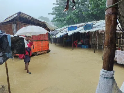
Coastal flooding in Bangladesh has once again turned deadly. Heavy monsoon rains triggered multiple landslides in Cox’s Bazar on July 6, 2026, killing at least nine people. Eight of the victims were Rohingya refugees living in overcrowded camps built on unstable, deforested hillsides.
The tragedy has renewed concerns about how exposed Bangladesh remains to seasonal flooding and landslides, a recurring danger that has shaped the country’s history for decades.
Background
Bangladesh sits at the delta of three major rivers, the Ganges, Brahmaputra, and Meghna. This geography makes coastal flooding in Bangladesh a near-annual occurrence during monsoon season.
The country has suffered catastrophic flooding before. The flood in 1988 submerged nearly two-thirds of Bangladesh and displaced millions. The 2004 Bangladesh flood was equally devastating, leaving large parts of Dhaka and surrounding regions underwater for weeks.
These historical disasters explain why images of Bangladesh under water are so familiar to the region. Every monsoon season, low-lying districts face the same risk, and this year has proven no different.
Details
According to local reports, eight of the nine victims died in three separate landslides in Rohingya refugee camps in Ukhiya, while another person was killed in a landslide in Cox’s Bazar town, all occurring between 1am and 4am on Monday. Fire service teams, police, and volunteers carried out overnight rescue operations across the affected camps.
The first landslide struck a shelter in Jamtoli Camp. A Rohingya family’s home was buried by falling earth, and rescuers later recovered the bodies of the father, mother, and their four-year-old son. Neighbours managed to pull two other family members out alive before emergency crews arrived.
A short time later, tragedy struck again. A seven-year-old child died after being buried under earth in a separate landslide at Kutupalong Camp. Community volunteers recovered his body after learning what had happened.
The deadliest single incident hit Balukhali Camp. Four members of one family, including two young daughters and two young sons, were killed when a landslide struck their shelter, and another relative was critically injured.
More than 1.2 million Rohingya live in overcrowded camps in Cox’s Bazar, the world’s largest refugee settlement, after fleeing a 2017 military crackdown in neighbouring Myanmar. Most families live in makeshift shelters made of bamboo and plastic sheets on steep, deforested hillsides that are highly vulnerable to landslides during the annual monsoon season.
The landslides did not strike only the refugee camps. A separate collapse in Cox’s Bazar town killed a local Bangladeshi resident and injured two family members when part of a hillside gave way onto their home.
Quotes
Local authorities have been urging residents in high-risk zones to relocate. Ukhiya Upazila Nirbahi Officer Panna Akter told reporters that there is a risk of landslides due to the heavy rainfall, and that the administration is regularly making announcements urging people living in high-risk areas to move to safe shelters.
Bangladesh’s refugee relief commissioner echoed similar concerns about ongoing danger. Mohammed Mizanur Rahman, Bangladesh’s refugee relief and repatriation commissioner, said authorities have already relocated at least 1,000 Rohingya refugees from landslide-prone areas to safer places and plan to move several thousand more in phases.
He added that officials are working to prevent further deaths as rain continues to fall across the region. Rahman said the priority is moving people out of high-risk areas as quickly as possible to prevent any more casualties.
Camp community leaders also described the chaotic rescue efforts. Enayet Ullah, a camp majhi, said volunteers worked through the night alongside fire service personnel to pull victims from the debris in multiple locations.
Impact
This disaster highlights a growing challenge: predicting and preparing for coastal flooding in Bangladesh before it turns fatal. Tools like Google’s Flood Hub, which uses AI-based flood prediction to forecast river levels, have been deployed in Bangladesh in recent years to give communities earlier warning.
However, landslides triggered by intense rainfall remain harder to forecast than river flooding. Unlike a flood alert that can track rising water levels over days, hillside collapses in the Rohingya camps often happen within minutes of saturation, giving residents little time to react.
The deaths come as renewed fighting in Myanmar’s Rakhine State raises concern of a fresh influx of Rohingya refugees across the border, which could add further pressure to already overcrowded camps built on unstable terrain. Bangladeshi authorities have stepped up monitoring along the frontier amid reports of people gathering near the border seeking to enter the country.
Regionally, this event adds to a troubling pattern. Officials in southeastern Bangladesh say that landslides triggered by monsoon rains have killed at least eight Rohingya refugees living in camps, underscoring how climate-driven disasters disproportionately affect displaced populations with the least infrastructure to protect themselves.
Aid agencies have long warned that deforestation around the camps, caused partly by refugees needing firewood and building materials, has worsened landslide risk. Environmental degradation combined with unusually heavy rainfall has created a dangerous combination this monsoon season.
Conclusion
The Bangladesh Meteorological Department has forecast more heavy rain in the coming days, prompting authorities to remain on alert for additional landslides and flash floods. This means the danger for the roughly 1.2 million Rohingya living in Cox’s Bazar is far from over.
Relocation efforts are continuing, but with thousands of families still living on unstable slopes, further tragedy remains a real possibility if rainfall continues at current levels. Aid organisations are expected to push for faster, more permanent housing solutions that move refugees away from high-risk terrain entirely.
For now, coastal flooding in Bangladesh, and the landslides it triggers, remains one of the most urgent humanitarian challenges facing the country each monsoon season, a pattern with roots stretching back to the historic floods of 1988 and 2004.
FAQs
What is the cause of landslides in Bangladesh?
Landslides in Bangladesh, particularly in Cox’s Bazar, are primarily caused by intense monsoon rainfall combined with deforestation on steep hillsides. In the Rohingya refugee camps specifically, thousands of shelters have been built directly on cleared, unstable slopes, since trees that once held the soil together were removed for firewood and construction materials. When heavy rain saturates this loosened earth, it can collapse suddenly, often at night while residents are asleep, leaving little time to escape.
What was the worst flood in Bangladesh?
Bangladesh has experienced several catastrophic floods throughout its history, but the flood in 1988 and the 2004 Bangladesh flood are widely considered among the most devastating. The 1988 flood submerged close to two-thirds of the country’s land area and displaced millions of people, while the 2004 disaster caused severe damage across Dhaka and surrounding low-lying regions, killing hundreds and disrupting the economy for months. Both events remain reference points for how vulnerable Bangladesh is to extreme monsoon flooding.
Why is flooding a problem in Bangladesh?
Bangladesh’s geography makes it exceptionally vulnerable to flooding. The country lies at the delta where the Ganges, Brahmaputra, and Meghna rivers converge before reaching the Bay of Bengal, meaning excess water from upstream regions, combined with heavy monsoon rain and rising sea levels, regularly overwhelms low-lying areas. Add to this dense population, poor drainage infrastructure in many districts, and deforestation in hilly areas like Cox’s Bazar, and both river flooding and landslide risk remain persistent, difficult-to-manage threats each year.